- Igneous rocks are formed from cooled magma. They appear as either Extrusive (cooled outside) like basalt or intrusive (cooled inside) like granite.
- Sedimentary rocks are formed from deposited sediments. They are usually described by their grain size and silica content. Examples include sandstone, mudstone, and conglomerates.
- Metamorphic rocks are rocks altered by heat and pressure. When an existing rock is exposed to new pressure and temperature conditions its structure and chemistry can change. Primarily we see increases in grain growth, foliation, and schistosity.
Metamorphism occurs when existing rocks are exposed to elevated temperature and/or pressure (enough to alter its mineralogy and texture, but not enough to melt it outright). The source rock (protolith) gets recrystallised while remaining solid. The dependence on temperature and pressure is why metamorphic rocks are so information-rich, as it encodes the path of the rock from formation to sampling.
As an example the pelitic (clay rich) sequence goes from low to high grade in this order:


To understand a metamorphic pelitic rock's history we can look at which minerals are present. Certain minerals are only stable within specific pressure-temperature intervals. So the presence of minerals can identify that the rock passed through said intervals. Chlorite appears at low grade, garnet at medium grade, staurolite & kyanite higher gridate, and sillimanite at the highest grades. If you can identify these minerals on a rock in the feld, you can determine the approximate metamorphic conditions the rock was exposed to without any laboratory work.
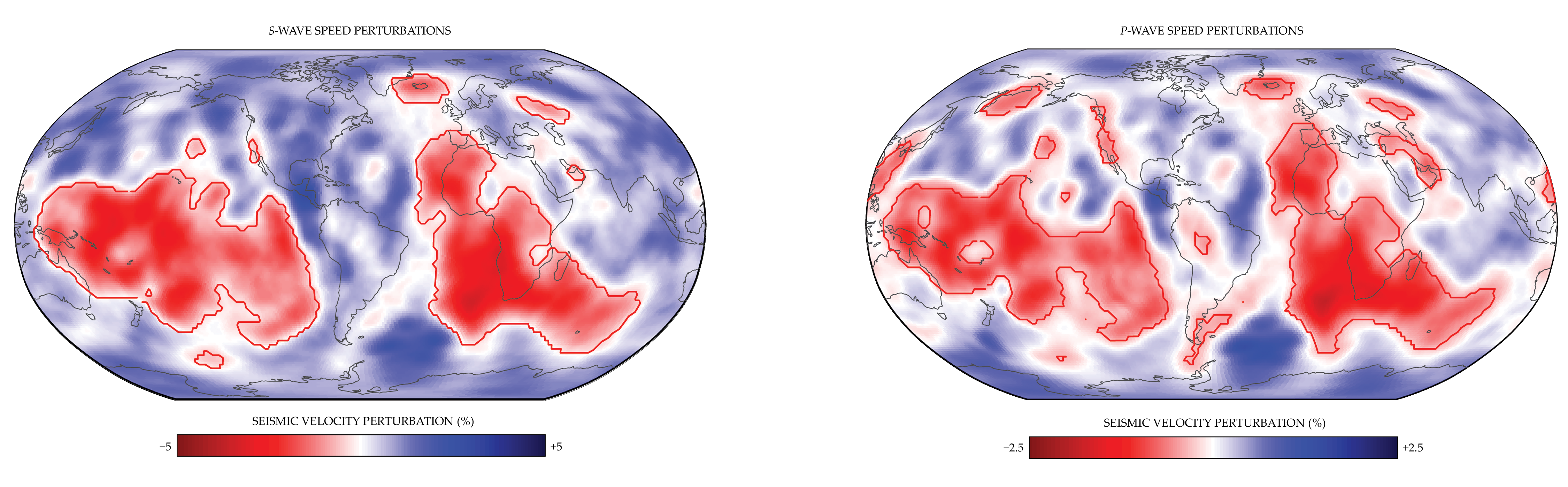
In mantle tomography, seismic waves generated by earthquakes are used to better understand thermal and chemical structures deep within the Earth's interior. By correlating large numbers of P and S wave arrival times, we can track the speed of the wave trough the earth's interior, and create models of unusual speed "anomalies". The effectiveness of this approach proves at sufficient scales, even primitive data, can be used to construct precise models. The 3D models and cross-sections generated by tomography are also cool to look at.
Cold/dense subducting slabs show up as fast anomalies and hot/buoyant plumes appear as slow anomalies.
Faults are breaks in rock along which a displacing motion has occured. Anderson's theory of faulting (1951) explains that you can classify faults to get an understanding of the principal stresses acting on rocks. This is particularly useful when you can find other features on the faults, or analyse many faults to get an understanding of how the stresses have changed through time.
Transcurrent Regime. The maximum stress (σ₂) is vertical. The faulting blocks move laterally past each other.
Extensional Regime. The maximum stress (σ₁) is vertical. The hanging block moves down relative to the footwall block.
Compressional Regime. The minimum stress (σ₃) is vertical. The hanging block moves up relative to the footwall block.

We can describe geological deformation in terms of three principal stress axes: σ₁ (maximum compression), σ₂ (intermediate), σ₃ (minimum compression). This modelling method is very flexible, being able to justify behaviour from fault scales all the way down to recrystallisation in metamorphic rocks.
| Axis | Name | Fault type when vertical | Notes |
|---|---|---|---|
| σ₁ | Maximum compression | Normal faulting regime | Rocks are generally pushed away from this direction. |
| σ₂ | Intermediate compression | Strike-slip regime | Rocks generally remain unmoved in this direction.> |
| σ₃ | Minimum compression | Reverse faulting regime | Rocks generally move towards this direction. |
One useful trick of this frmework is that veins (which infill openings in the rock), almost always open perpendicular to σ₃. So you can determine σ₃ just from small outcrops.
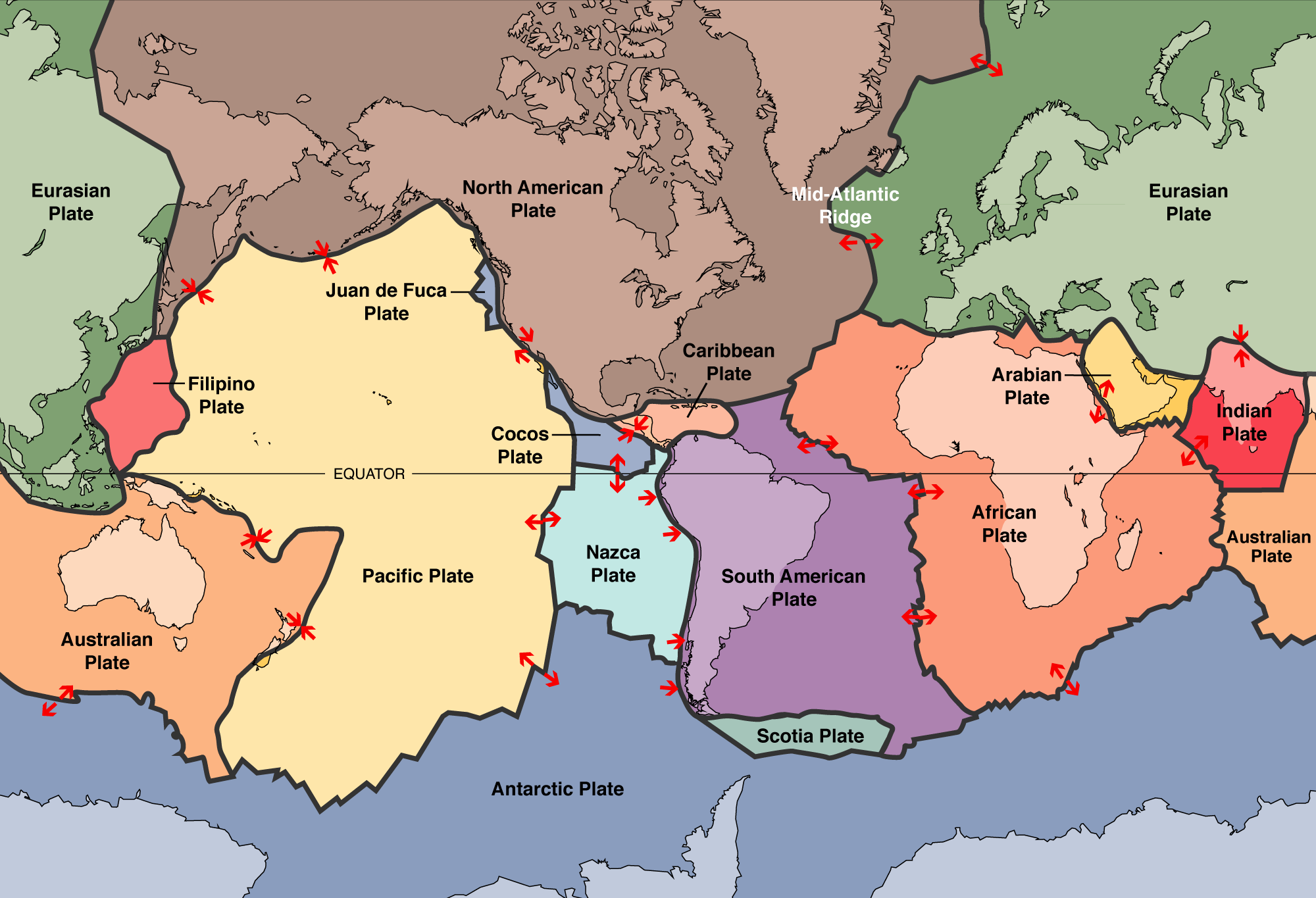
Most interesting geological activity (such as volcanoes, earthquakes, and mountain-building) occurs at plate boundaries. Broadly we can classify each boundary in terms of the dominant behaviour:
- Divergent boundaries: Here plates are moving apart, which generates new rocks from the magma that moves upward from inside earth. For example Iceland sits on the Mid-Atlantic Ridge and you can find locations where you can descend into large voids left by the plates as they move apart.
- Convergent boundaries: Here plates collide into one another. When oceanic crust is involved in this collision, the denser plate us usually subducted under the more buoyant one. This can form volcanic arcs, accretionary wedges, and deep-focus earthquakes. When two continental crusts collide mountain belts are built instead, such as the himalayas forming from the collision of India and Eurasia.
- Transform boundaries: Here plates move past one another. Shallow earthquakes with high magnitudes are relatively common here. One example is the San Andreas Fault between the Pacific and North American crust.